As far as autumn days go, we were treated to one of the best - clear skies and, remarkably for this area, no wind.
Ian, Alison, and myself had made an early start in order to meet a dinner date at the other end of the day and, having driven to the Hawdon Shelter at the entrance to the Hawdon Valley, hit the trail shortly after 8am.
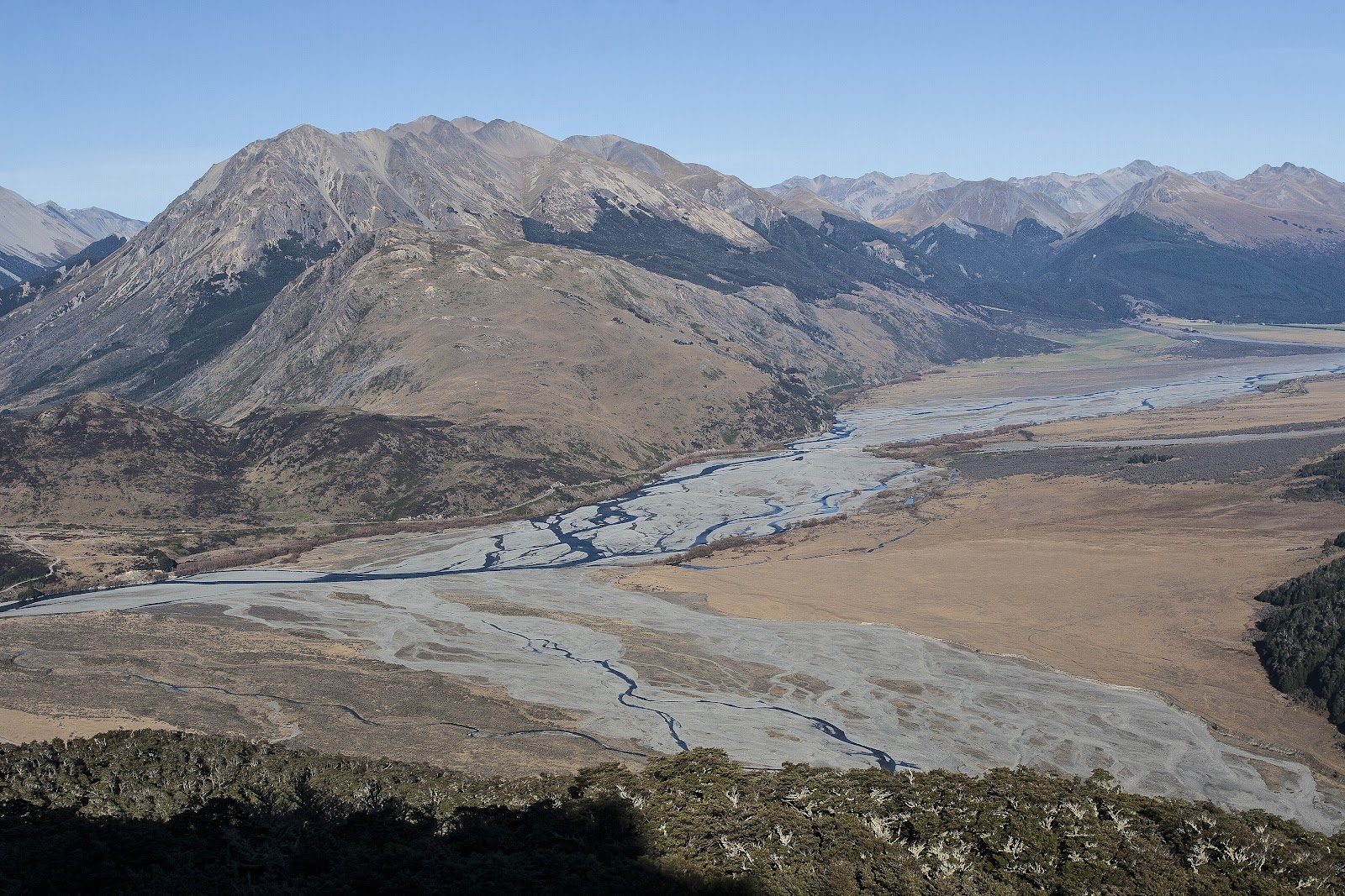
Woolshed Hill was the goal. Although the summit stands at a modest height of 1429m, its' location means it commands wonderful views over the surrounding area, particularly over the Waimakariri River as it sweeps past the base of the mountains in a braided, winding trail of blue.
A short stroll down to Kidson House (or Lodge as it's marked on maps) provided a warm up for the legs before the climbing began. There was no gentle introduction to this climb, we were straight into the steep stuff. My altimeter indicated I climbed 60m height in the first 3 minutes of walking, and the gradient didn't ease at all for the first hour, in which we climbed around 350m (with regular stops for a chat and to let the breathing settle!).
At the 940m contour we reached a plateau in the bush. This proved to be a transition point of sorts, where we left the steep slopes below us and ventured forth along much gentler ground. While still uphill, after all we did have the best part of 500m height still to climb to reach the summit, the gradient eased and the tramping was a delight, even more so when we broke out of the bush at just above 1000m. Here we were greeted by the golden spray of
Dracophyllum, which painted the hillside with its' orange tones.
It was a truly stunning morning in the mountains. The sun, although shining brightly, was not yet generating a lot of heat, making for extremely pleasant tramping as we made our way up the open ridge. The ridge granted wonderful views all the way up the Hawdon Valley and across to the adjacent peaks lining Sudden Valley, but the most expansive view lay behind us, with the Waimakariri River cutting through the landscape, seemingly at our feet, and stretching away east and west on its' march from the mountains to the sea.
The ridge became rockier as we passed over Pt 1296m but was never difficult and we soon came to the base of the final climb to the grassy summit. We met a hunter here on his way down after an unsuccessful morning out, despite plenty of fresh sign, although on a morning like it was there could be little to complain about and he'd had an enjoyable walk.
The final 50m or so up onto the summit was of a steeper grade, although certainly not as steep as lower down in the bush, and before long we were stepping out onto the summit. As always, it was a fine feeling attaining the summit, even one so easy to reach and, having made decent time, we sat down to enjoy our time there over a leisurely lunch.
360 degree views were our reward for our efforts - north up the Hawdon Valley and to the Savannah Range, east into Andrews Stream, south over the Waimakariri to the Cass basin peaks and the Black Range, and west across the Hawdon to the Polar Range - it was all encompassing and magnificent.
With lunch behind us there was just the matter of the descent. We expected to make fast time back along the ridge to the bushline, and we did so without incident, other than meeting another party on their way up to camp on the tops.
The day was warming now, being just after midday, and we were pleased to plunge back into the cool of the bush. From there, all that remained was that knee-jarring descent back to the car - it was just as steep going down as it was going up!
Another great day out, hopefully I'll be back this way again, there's plenty to explore along the tops beyond Woolshed Hill.
 |
| The entrance to Sudden Valley, with Mt Foweraker (1804m) and The Pyramid (1608m) presiding |
 |
| Waimakariri/Hawdon confluence beneath Mt Misery (1765m) |
 |
| View into the Hawdon Valley from the ridge leading to Woolshed Hill |
 |
| Gaining height along the ridge, spectacular scenery |
 |
| Tarn on the ridge |
 |
| Tarn on the ridge |
 |
| Looking back over golden scrub on the ridge |
 |
| Yes, I was there! (thanks Ian, my attempted selfie was an epic fail!) |
 |
| Into the rocky stuff around Pt 1296m |
 |
| Waimakariri River as it sweeps past Mt Binser (1860m) |
 |
| Looking back along the ridge |
 |
| On the summit of Woolshed Hill, looking north/northwest up the Hawdon |
 |
| My proposed route to access the Savannah Range |
 |
| View along the tops north of Woolshed Hill towards the Savannah Range |
 |
| Polar Range - Mts Wilson (2035m) and Scott (2009m) just left of centre |
 |
| Looking down into Andrews Stream, Brown Hill (1716m) left of centre and Pt 1709m on the right |
 |
| Looking down our ascent ridge, with the Black and Grey Ranges in the distance |
 |
| Panorama from the summit of Woolshed Hill |
 |
| Ian on the descent, Mts Wilson and Scott in behind |
 |
| Cruising along the ridge, delightful tramping country |
 |
| Negotiating a step on the steep bush descent |
 |
| Steps like this were typical of the track up through the bush |
 |
| Steps like this were typical of the track up through the bush |
 |
Spotted this fine specimen on the way up & was treated to great lighting on our return
|
 |
Crown Copyright - Land Information NZ
Access: Drive on SH73 towards Arthur's Pass and take the signposted turnoff to the Hawdon Valley. Follow signposts to the shelter and carpark.
Time: Hawdon shelter to summit 3hr, return 2hr
Map: BV21 Cass
Hut: None, although Hawdon Shelter can provide cover and does have a fireplace.
|