Well, here we are again - another tramp, and another trip up the Hawdon Valley. It seems Hawdon Hut is almost becoming a second home, with this my third trip up this valley in less than 2 years. The point of difference this time was that we were taking a group of young lads (12-15yr olds) from Oxford ICONZ on what was for many of them their first tramping experience. Although not actually involved in the group myself, I was invited along as a leader, probably because I had tramping experience...and gear!
ICONZ is an adventure programme for boys in School Years 4-6 and 7-9 (2 separate groups, with girls groups running also now), and is a modernised version of Boys Brigade. Weekly sessions involve fun activities and games, with badges being earned along the way, and also a devotional time where the boys learn about the Christian faith.
As the tramp to Hawdon Hut is an easy 3 hour trip we had decided to extend the trip by driving up to the shelter at the start of the route on the Friday night and give the boys a night of camping either in or around the shelter before heading up-valley to the hut the next day. Our group of 11 (6 boys, 5 leaders...excellent ratios if anyone official decides to read this!) arrived at the shelter just as darkness was setting in. Excitement levels were high, food quickly appeared, and supper/dinner consumed by those of the insatiable type...or those who had just brought way too much food! Having surveyed the shelter, and decided sleeping on a concrete floor or wooden bench amongst a group of rowdy lads wasn't that appealing, I pitched my tent on the terrace behind the shelter, anticipating a night of bliss on what was shaping up as a clear, calm, mild night. Soon another tent was pitched, and a rough bush bivvy constructed in the trees, before we all sat with warm brews in our hands in front of the carefully controlled fire in the shelter's open fireplace. It was a superb night to be camping, with only the never-ending cries of two morepork providing any disturbance.
Saturday dawned cool but clear, although a glance further up the valley showed signs of some cloud building to the west. We were away surprisingly early, the boys were keen and ready to go, and we bolted out of the gates at around 8.50am. After about 5 minutes we got to the inevitable river crossing to start the tramp, still unavoidable despite the drought conditions. Two particularly keen lads decided that wet feet were the way to go, and spent the rest of the day finding ways to walk in the water rather than alongside it. Progress was initially quite slow as the boys got used to the fact that they had to carry all that food they'd brought with them on their backs! A few minor grumbles here or there, but for the most part they kept going - so long as there were rest stops every 20-30 minutes.
After about an hour (and 2 stops) we crossed over to the true left, finding the pleasant grass flats which lead to the forks with the East Hawdon Stream. Quick time was made here and we reached the East Hawdon around 10.45am, at which point we decided another rest was called for. The boys were keen to find out how far we'd come (or perhaps they were more interested in how far to go!), so maps were produced with pleasing results - about 5.5km behind us, only 3.5km to go.
Travel through the upper part of the route was straightforward, with the boys eager to reach the hut and drop their packs, so decent time was made. The old hut site was passed, and there was much excitement (and relief) to hear that it was only 15 minutes more to the new hut. Discovery Stream held merely a trickle of water so I had great pleasure in arriving at Hawdon Hut with dry feet, around 3 and a half hours after setting off. It wasn't long before lunch was devoured and the boys were off to explore the river, returning with satisfied grins having successfully dammed the river. We had the whole afternoon to fill in, and put forward the suggestion of tackling the uphill climb up to Walker Pass to experience how different weather conditions can be up on the tops (a nice strong wind was now blowing). This idea was met with such little enthusiasm that it was no point pressing the issue, so idea #2 was to build some shelters in the bush around the hut. This actually served a double purpose - as well as learning how to build such a shelter there was also the possibility of sleeping in them, as another large party had arrived at the hut making for a full house. As it turned out the boys were dead-set on sleeping in the hut, having commandeered a bunk-room for themselves, but 3 of us leaders found the idea of a night in the bush more appealing than a night in a crowded hut full of young lads, so we readied ourselves for a night in the open.
The rest of the afternoon was spent on a quick lesson in animal tracking from our resident hunter-gatherer Troy, and having the devotion down by the river - the story of Nicky Cruz is quite something!
It was late afternoon by this time, so we returned to the hut for dinner followed by the standard night of cards. Quite a rowdy bunch these boys, so it was enjoyable to escape outside to sleep.
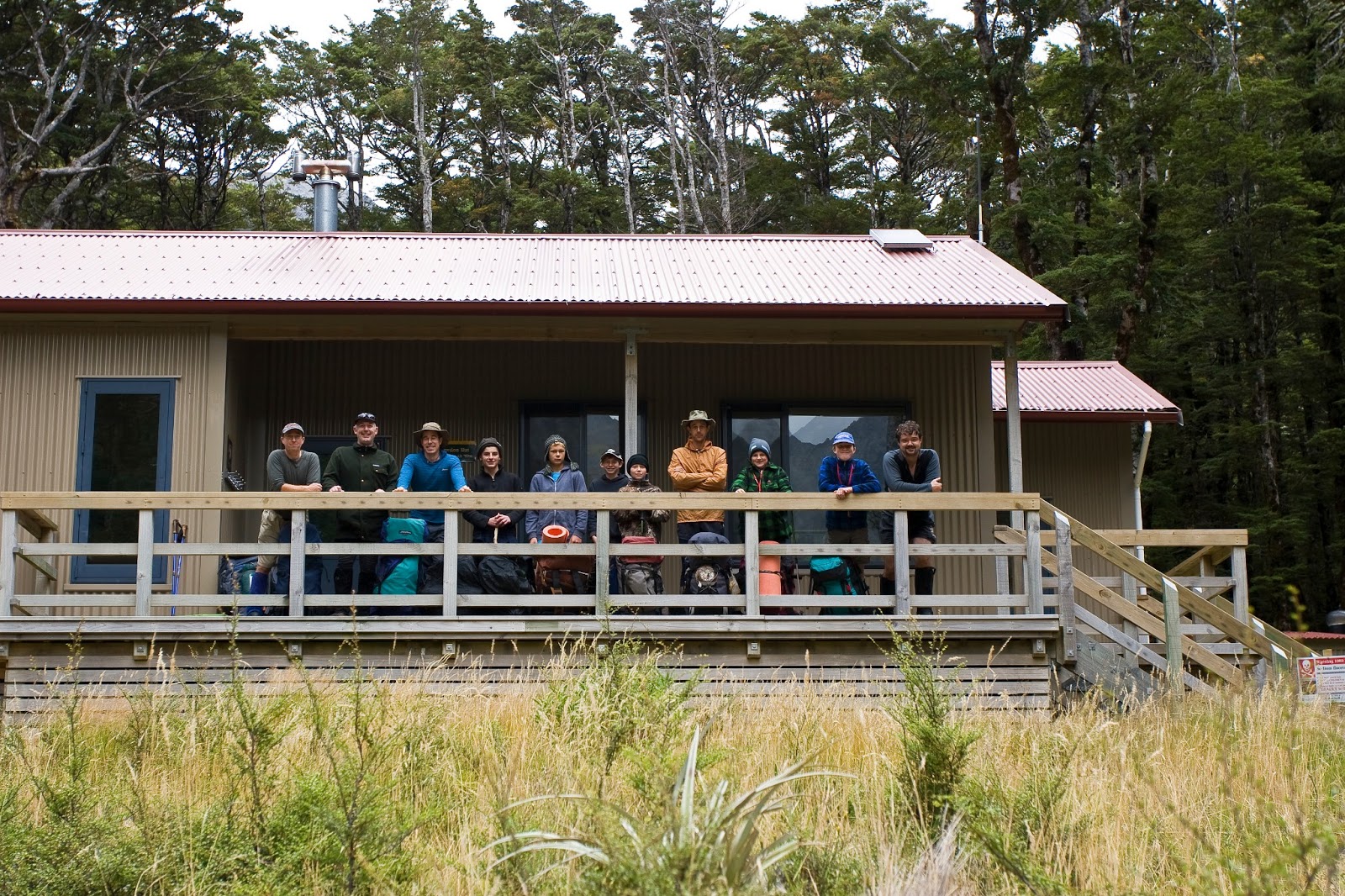
A strong nor-wester blew through the night and into Sunday morning, bringing with it light drizzle at times, but by the time we had packed up, cleaned the hut, and taken the obligatory group photo, things were looking brighter. Our tramp out was exceptional, lighter packs made for faster (and happier) travel, so quick in fact that we reached our intended lunch spot by 10.30am so carried on, stopping for lunch on grass flats just after crossing to the true right of the Hawdon. It hardly seemed worth stopping, but we had promised the boys that we'd be stopping for lunch so we made good on the promise, and it gave the opportunity to finish the devotion story. The half hour stop seemed to knock the stuffing out of some of the boys, as their bodies struggled to get going again despite being so close to the end, and the final leg of the tramp was a rather quiet one.
All in all a successful, enjoyable weekend away, and hopefully one that will be remembered fondly by all those involved.
 |
| Devotion time at the Hawdon shelter |
 |
| About to set off up the Hawdon on Saturday morning |
 |
| Rest stop early in the tramp, with the Hawdon River in low flow |
 |
Map reading during a well-earned rest stop just after crossing the East Hawdon Stream
|
 |
Rougher terrain as we progress further up the Hawdon, with cloud building from the west
|
 |
| Leading the way through the upper Hawdon |
 |
| Arrival at Hawdon Hut |
 |
| Cards and candles - a common sight in backcountry huts |
 |
| The group before departure from Hawdon Hut |
 |
| Boys will be boys - exploring from the riverbed |
 |
| Comfortable quarters for a night out in the bush |
 |
| Scrog stop on our way back down the Hawdon |
 |
Nearly there! - crossing the flats in the lower reaches of the Hawdon Valley
|
 |
Crown Copyright - Land Information NZ
|
Access: Take SH73 from Christchurch towards Arthurs Pass. Turn off the signposted exit to Mt White and follow the road to the Hawdon shelter.
Time: 3hrs to Hawdon Hut
Map: BV21 Cass
Hut: Hawdon (20 bunks)