
The name Zampa on the map had often intrigued me, but it took only a short time to discover its' likely origins. Zampa is the name of an opera comique by the French composer Herold, first performed in 1831. Given that the peak is located in what I would call the cultural corner of New Zealand's backcountry, it seems a likely reference.
Cultural references abound in this area. Names like the Opera and Libretto Ranges speak for themselves, and with peaks such as Faust and Trovatore there is plenty to interest those who are musically inclined.
Moving northwards we enter the literary world - the Spenser Mountains, named after the 16th Century English poet Edmund Spenser. While perhaps not as well known as the likes of Milton or Shakespeare, Spenser's most significant work, the epic allegorical poem The Faerie Queene, obviously struck a chord with the early surveyors as numerous peaks in the Spenser Mountains bear the names of characters in this work - Gloriana Peak, Mt Una, Duessa Peak, even the title Faerie Queene itself.
Lake Tennyson is also not too distant - another literary reference.
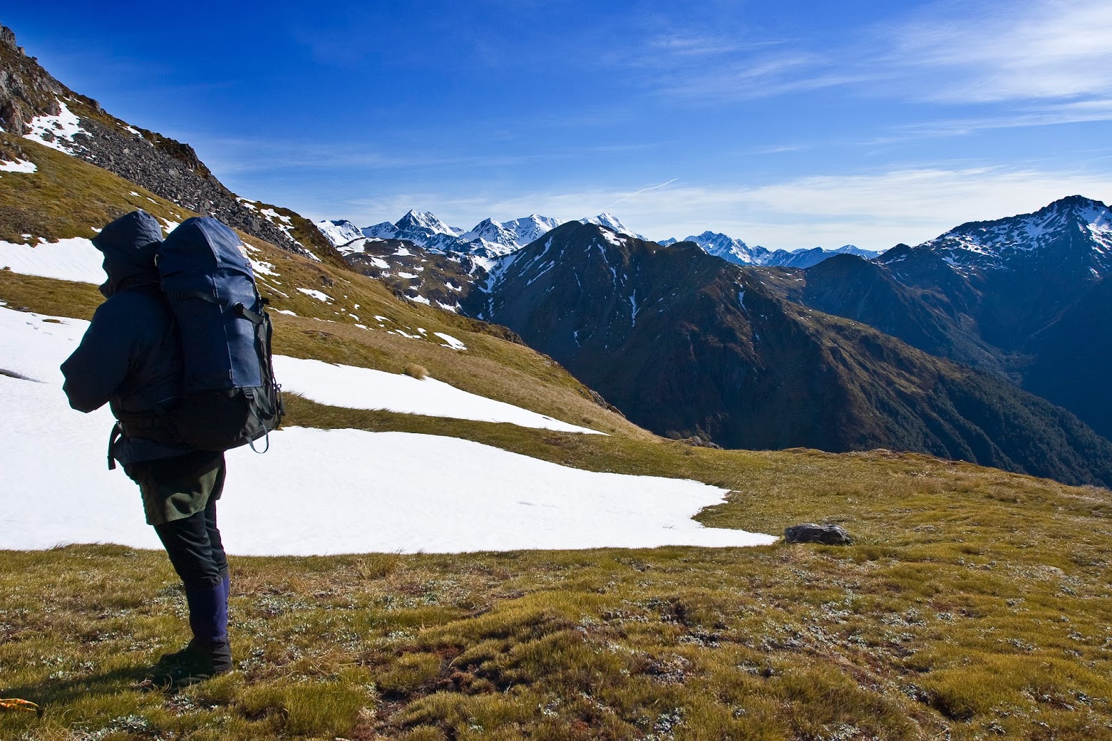
The plan was relatively straight forward - drop down to the river at the Cannibal Gorge swingbridge, make our way upstream to a major side stream, rock hop our way up to its' head, then climb tussock slopes to gain a saddle which would lead through to our intended campsite. Day 2 would then have us gain the ridgeline and follow it along until looking down to Ada Pass, drop down through scrub and bush to reach the hut there, then take a relatively easy stroll back out along the St James Walkway. Sounds idyllic, but with around 750m height gain over untracked and unmarked terrain required to reach our campsite, and a further 200m to gain the ridgeline, we knew we had some hard work ahead of us.
We arrived at the Lewis Pass layby mid-morning, and were greeted with bright sunshine and a cold westerly wind, which hit with a bit of a shock as we exited the warm confines of the car. After running all the last minute checks (including making sure nothing of value was left in the car) we hit the trail at 11am.
The first section of track follows the start of the St James Walkway, an easy (and popular) 4-5 day tramp which mostly involves flat valley walking alongside rivers or on cattle flats and exits at Boyle Village on the main highway. About 20 minutes of zig-zagging downhill from the carpark led us to the Cannibal Gorge swingbridge spanning the Maruia River Right Branch. It didn't take us long to realise there was no easy way down to the river from here - the bridge is anchored at the top of bluffs on the true left but looked more promising on the other side.
Deciding to have a look, we made our way across what I would have to say is the sturdiest swingbridge I've ever been on, which is understandable given that it would be subject to some decent snow loading over winter. Across the river there was an easy route down to the riverbed itself but, resigned to the fact we were now forced to cross the main river to get to the side stream up to the tops, we decided to stick to the (well-formed!) track for now rather than pick our way up the riverbed. All we had to do was keep an eye out for the side valley and ford the river there.
It was only 15-20 minutes along the track before I noticed that we were now across river from the side stream we were to take. There was just the small problem that we were probably around 100m away from the river, and about 70m vertically above it. There was nothing else to do but bush bash our way down to the river. The bush was very open, and easy progress was made, but when we reached the river we were still 20m or so above it with no way down. Undeterred, we set off downstream and tried again a little further along. Here Brent attempted to scramble down a 10m near vertical bank with some trees and scrub for handholds, only to find the way still barred by a drop off at the edge. From here we could see the side stream as it joined the main river, frustratingly close but still so far.
We continued downstream, following the terrain as it sloped down to meet the river, until finally we emerged at river level at around BT23 515097. Just as we were about to leave the bush we were surprised to hear voices and then see 3 people making their way up the river bed. As it turned out they were taking the same route as us, so introductions were made but our gentler pace meant we did not get close enough to speak to them again all day!
Now that we were down at the river we needed to cross it. While running clear and not particularly high (about mid thigh for me), it still had a strong flow and was icy cold - classic, snow-fed New Zealand high country river. We linked up and waded in and safely forded with no dramas, just numb legs.
Travel was straight forward up the streambed, which was quite open and bare in its lower reaches. We climbed at an easy gradient, rock-hopping our way upstream, criss-crossing the stream as needed to take advantage of the easiest travel. At one point, maybe half an hour up from the confluence with the main river, the stream cascaded down more steeply, hemmed in by much larger boulders. We avoided this by making a short, steep climb up onto a terrace and sidled along for a short while before dropping down a rock/scree slope where numerous gullies had been incised into the slope. From here it was back to the streambed, steadily working our way upwards. After about an hour of easy tramping we stopped for lunch at around 970m, just at the point where the valley begins to narrow and steepen.
 |
| Tarn at the start of the track, Zampa (1710m) at right |
 |
| Looking up the Maruia River Right Branch towards Zampa, taken from the swingbridge |
 |
| Brent tries to negotiate a way down to the river but finds we're still bluffed |
 |
| So close and yet so far - there's our side stream but we still can't get down |
 |
| The open streambed in the lower reaches of the side valley that leads up to Zampa tarn |
 |
| Nice little spot for lunch at 970m, with the narrowing stream ahead |
 |
| View back down the valley from our lunch spot |
After just under an hour the bush started to give way to scrub, our view of the upper valley slowly being revealed as we made our way through thigh high tussocks now. At around 3pm we reached the head of the valley, an impressive mix of rock walls and bluffs on one side and scrub and tussocks on the other. We paused for a moment to check the map and confirm our route - we had seen the other party ahead but it seemed at first glance that they were taking a different route to the one we were intending. A quick check of the compass however told us that they were indeed showing us the correct line.
We set off, ready to tackle the very steep tussock slope. The grasses were extremely slippery, as those who have experienced wet tussock and snow grass can confirm, resulting in tediously slow progress, particularly in my case, hampered by a dodgy knee that was now deciding to protest at having to push me uphill so steeply! When I finally made it to where Brent was perched we briefly recounted our adventures on the way up - both of us having multiple slips, saved from a long slide down only by the remarkable strength of the tussocks, which provided secure handholds.
By now we were most of the way up, and another short climb took us round a rock outcrop and onto a beautiful, flat terrace, high above the valley floor. We paused to take it all in, the views magnificent. Not too far above us lay our path through to the tarn, and our home for the night, while following the line of our valley led the eye to distant Mt Technical, rising high above Lewis Pass. We lingered a while, savouring the moment, ample reward for the effort required to get here.
Time, and a cool wind, moved us on. We angled upwards and across to the right, aiming for the nearby saddle. A strong animal trail led us over to the saddle, on a level sidle at around the 1490m contour. In just a few minutes we were there, standing looking down into the opposite valley. The view was stunning - in a moment we were taken from grassy terraces to the mountain grandeur of the snow-capped Spensers.
After a quick pause for photographs we pressed on, out of the sun now we were eager to reach camp. A short, slightly descending sidle took us to a couple of small tarns, then climbing over the next lip revealed the superb sight of the large tarn that was to be our overnight abode. Nestled in a basin beneath Zampa, it truly is a stunning location, but before we could bask in its' beauty there was the small matter of finding a campsite and pitching the tents - in a reasonably strong, and equally cold, wind. It didn't take long to settle in before hunkering down out of the wind to cook up dinner and some brief conversation, before the plummeting temperature sent us to the comfort of our tents for the night.
It was a slightly wild, windy night - more so than we had expected - but the tents stood up well. My watch gave me a reading of 1degC in my tent, so while not cold I wasn't exactly warm either.
 |
| The stream gains beauty as we near the head of the valley |
 |
| Surveying the route to the saddle (center image) from the valley head |
 |
| Rewarding views at the top of the steep tussock climb, Mt Technical (1870m) in the distance |
 |
| On the saddle at 1490m at the valley head and the view across to the Spenser Mountains |
 |
| Tighter zoom, again from the saddle |
 |
| Campsite beside Zampa tarn and the last of the day's sun |
Once the sun had arisen it transformed the feel of the basin we were in into a place of true beauty, the hills bathed in its' golden light, glowing warmly and making for good photographic conditions. I tried to make the most of it, while at the same time being mindful of the length of the day we had ahead of us and the need to get packed and away.
We shouldered packs and set off at 8.30am and started the steady but comfortably graded climb up to the ridgeline. Again with no marked trail we were left to our own decisions when it came to route selection, which was simply a case of choosing the least steep path upwards and avoiding the areas of snow whenever possible. It was interesting to note that despite a reasonably broad slope leading up to the ridgetop we constantly seemed to be following in the footsteps of the party we had met the day before who we had discovered had chosen not to camp but to continue on to Ada Pass Hut for the night - a long day but then again they were much younger and fitter than us.
Height was gained quickly - in only 10 minutes we were a good 70m above the tarn - and from then on it was straight forward route finding up onto the ridge, which we gained after 1 hour of surprisingly easy tramping. Only once did we utilise our ice axes, merely as a precaution on the final 20m below the ridge as we crossed a simple snow field which, although not icy, had a firm crust to it and very poor runout straight down onto rockfall - better to be safe than sorry.
We reached the ridge at Pt 1662m and were greeted by grand views over all the ranges and peaks of the Lewis Pass area - the Freyberg Range seemed a mere stones throw away, its' peaks piercing the strands of low cloud that clung to the slopes around the valleys, while the view to the north of the high, snow covered summits of the Spenser Mountains drew us onwards, and we started our trek along the ridge.
It was turning into a perfect day in the mountains, the wind now light and the cloud now all but gone, as we dropped down along the ridge. We planned to sidle any rock outcrops on the ridge on the western side, thus avoiding having to traverse the snow slopes that covered much of the eastern aspects.
We encountered our first obstacle just south of Pt 1687m, a large section of broken rock barring the way along the crest of the ridge. It was an easy decision to descend and sidle below it, but once down we were confronted by significant rockfall that had come down. We decided to scramble through it, the alternative being a descent of perhaps another 50m to cross below the boulder field. It was slow but easy scrambling and we re-gained the ridge just below Pt 1687m and the easy travel resumed. From there it was simple ridge travel along a broad ridge with the occasional sidle just below the ridge crest when necessary. From Pt 1692m we dropped into quite a low saddle and instead of following back up along the ridge it appeared easier to cross easier slopes east of the ridge and work our way back up to Pt 1681m, passing the small tarn marked on the map, although it was snow covered on our visit. We stopped here for a short rest, 3 hours of superb tops tramping, and yet another stunning place to stop and linger on this trip.
From the summit of Pt 1681m we could see all the way back along the Zampa tops to the tarn we had left such a short time ago. At our feet lay the tarn speckled flats of Ada Pass, and rising directly above the continuation of the Spenser Mountains in all their glory - Gloriana and Faerie Queene dominated the view, their majestic summits rising clearly above the surrounding peaks.
 |
| Dawn breaks over our campsite, with cloud blowing in over the saddle we crossed |
 |
| Morning rays light up the basin |
 |
| Morning rays light up the basin, with clear skies to the north a blessing |
 |
| Starting the climb up to the ridgeline, our campsite to the left of the tarn close to the outlet |
 |
| Planning the route up to the ridge, Pt 1662m is the snow capped peak left of center |
 |
| Looks like being a spectacular day in the mountains |
 |
| Looking down the Henry River, with Philosophers Knob (1921m) at left |
 |
| Gaining the ridge at Pt 1662m and the view of the ridge ahead |
 |
| Looking across to the Freyberg Range |
 |
| Our route up to the ridgeline, tarn visible below, Zampa just out of shot to the right |
 |
| Part way along the ridge, Gloriana Peak and Faerie Queene majestic, Pt 1681m left of center |
 |
| Stunning views from Pt 1681m where we started our descent, Ada Valley running off to the right |
 |
| View back along the Zampa tops, tarn just visible on the left |
 |
| Looking west from Pt 1681m |
 |
| The author atop Pt 1681m (thanks Brent for taking this one!) |
 |
| Panorama of the Spenser Mountains as seen from Pt 1681m |
At around the 1510m contour the spur narrows and while not technically difficult requires some scrambling around loose, crumbly rocks - check your hand and foot holds before committing as the drop offs on either side are long and steep.
Beyond here the spur becomes a broad face of long tussocks, scrub, and loose scree. It also descends very steeply, much more steeply than we were expecting. At least being north-facing the ground was dry, so the tussocks not slippery, but it was still slow going with more cries of protest from my now very painful knee. Eventually though, with the help of gravity, I made it down and found Brent scouting the bushline for signs of a marked entry point to our next challenge - the bush bash down the final 300 vertical metres to reach Ada Pass Hut for a well earned lunch.
With no sign of any marked route at all we took a rough bearing off the peaks across the valley and stepped into the bush. It was immediately apparent that the wild spring winds had battered the bush here as well, giving us plenty of windfall to contend with. That aside, it was pretty easy going through relatively open bush, making decent progress on an angle down and veering slightly to the right most of the way down.
At around the 1100m contour the bush thickened ahead of us, with significant regeneration slowing progress somewhat. Again the line to the right appeared easiest, although instead of taking us down onto flatter terrain above the hut as the map indicated, it meant we ended up dropping down the side of the spur. Given that the alternative was pushing through thick bush I think this route worked well.
After 30 minutes in the bush we emerged at a small stream. While not entirely sure at first if it was a side stream or the main river it really didn't matter - if it was a side stream then if we followed it down it would take us to the river, and of course if it was the river then all was well.
A quick glance at the map revealed it to be a side stream, which took us almost directly to Ada Pass Hut, so after about 5 minutes of pleasant sloshing about down the streambed we saw our first track markers of the day - we had reached the St James Walkway. Turning left onto the track (after a short deliberation as to which direction the hut lay) we arrived at Ada Pass Hut at 1.30pm, exactly 5 hours after leaving our campsite.
Ada Pass Hut stands in a nice clearing at the bush edge, set just back from the stream we had followed down, and commands grands views across the valley to the north. It has 14 bunks and a nice woodfire but would likely be quite cramped when full as there was not a particularly large area for cooking and dining. As is typical of this area of the country, the sandfly population is very healthy.
After a quick lunch stop we moved on, to linger too long would probably have our bodies totally seize up! Our afternoon was expected to be easier going than the morning, with a formed track to follow all the way out to the car, which was still about 4 hours away.
The section from Ada Pass to Cannibal Gorge Hut was a breeze, almost dead flat all the way. The track is mostly close to the river, sometimes in small pockets of bush but often passing through attractive grassy clearings. After 1 hour of delightfully easy tramping we reached Cannibal Gorge Hut, located at the top end of a large grassy terrace a short distance from the river.
The hut has a similar layout to Ada Pass Hut but is slightly bigger all round, with 20 bunks and a larger living area. The porch area appeared more sheltered from the sun than the one at Ada Pass, and the picnic table in front of the hut would get well used on fine days.
We didn't stay too long, just to sign the log book and take a few snaps of the hut, before we set off on the last leg of our journey - the trip through Cannibal Gorge, so named due to the discovery of human bones in the gorge, most likely from the days when Maori tribes used these valleys and passes as access to and from the West Coast on greenstone expeditions. The information board at the swingbridge suggests that one tribe may have ambushed another in the area and, being hard up for meat sources, consumed their victims.
There are 9 side streams marked on the map through this section, and the track crosses numerous avalanche paths. Despite being on a well formed track, it was a taxing trip through the gorge. Each side stream is cut quite deeply into the hillside so despite the fact that from the start of the gorge to the end there is very little height difference, the need to descend then re-climb back out of each gully made for a lot of up and down travel. Add to this some significant avalanche damage in places and you've got a more rugged than usual experience on what is generally a very good track.
This being said, we made steady but not exactly fast progress through the gorge, but were very pleased to reach the point where we started our gradual descent back down to the swingbridge across the river, knowing that we were nearly at journey's end. Once across the bridge all that remained was the 150m climb back up to the carpark, not exactly ideal after just over 9 hours on the go but the will to keep the body moving to reach the car overcame the painful cries of an aching knee.
Just over half an hour of slow but steady plodding had us back at the carpark, and the dismay to find our car had been broken into (and the 6 others in the carpark judging by the number of piles of glass left behind). Hardly a welcome end to what had been a superb tramp - one I would highly recommend.
 |
| Halfway down the steep tussock slope on our descent from Pt 1681m to the bushline |
 |
| At the bushline (1300m), looking back up the slope |
 |
| Ada Pass Hut - time for lunch |
 |
| View from Ada Pass Hut |
 |
| Cannibal Gorge Hut |
 |
| Avalanche and flood debris in Cannibal Gorge, but the bridge is still standing... |
 |
| ...helped by some good Kiwi ingenuity! |
 |
| Crown Copyright - Land Information NZ |
Time: Carpark to tarn 6hrs, tarn to Ada Pass Hut 5hrs, Ada Pass Hut to Cannibal Gorge Hut 1hr, Cannibal Gorge Hut to carpark 3hrs
Map: BT23 Lewis Pass
Hut: Ada Pass (14 bunks), Cannibal Gorge (20 bunks)